Flood Risk Management Plan of the hydrographic district of the River Po
General information
Plan: Flood Risk Management Plan of the hydrographic district of the River Po
Developer: Autorità di bacino del fiume Po
Planning sector: Soil
Description: The Hydro graphic District of the River Po extends in the Valle D'Aosta, Piemonte, Lombardia, Liguria, Emilia-Romagna, Veneto, in the Autonomous Province of Trento and in Toscana and also affects the territories of Switzerland and France. The plan aims at reducing the potential negative impacts of floods on human health, territory, property, environment, cultural heritage and economic and social activities.
Related website: Piano di gestione del rischio di alluvioni del distretto idrografico del Fiume Po
Deadline for submission of comments: 07/10/2015
mail
Territories and marine areas
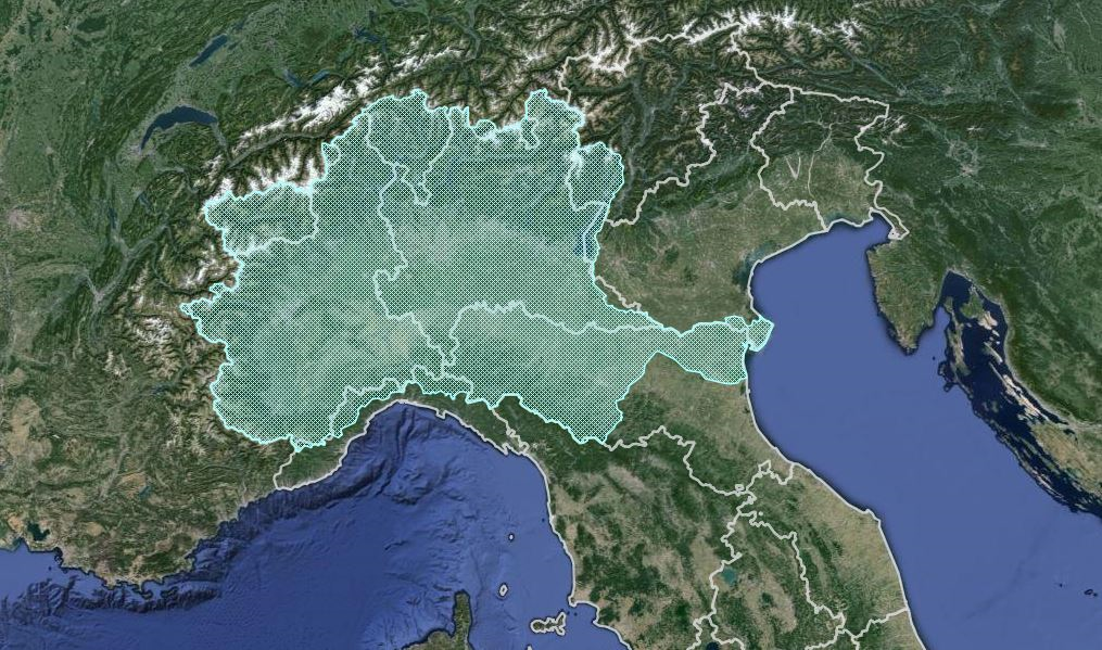
Regions: Liguria, Trentino Alto Adige, Emilia Romagna, Piemonte, Lombardia, Valle d'Aosta, Toscana, Veneto
Provinces: Trento, Brescia, Reggio Emilia, Lecco, Como, Cremona, Mantova, Modena, Verona, Pistoia, Varese, Ferrara, Pavia, Piacenza, Milano, Genova, Savona, Imperia, Sondrio, Rovigo, Bergamo, Parma, Novara, Lodi
Municipalities: all municipalities of Liguria, Trentino Alto Adige, Emilia Romagna, Piemonte, Lombardia, Valle d'Aosta, Toscana, Veneto
Marine areas: Mar Adriatico Settentrionale
Select procedure
| Procedure |
Procedure Code |
Starting date |
Stage of the procedure |
|
|
| Strategic Environmental Assessment |
2975 |
12/03/2015 |
Concluded |
Procedure details
|
Documents
|
| Procedure Code (ID_VIP/ID_MATTM) |
2975 |
| Transboundary consultations: |
Il Ministero degli Affari Esteri e della Cooperazione Internazionale ha notificato l'avvio della procedura di VAS ai sensi del Protocollo VAS alla Convenzione di Espoo alla Francia (in data 10/09/2015) ed alla Svizzera (in data 09/09/2015), con richiesta di esprimere il proprio interesse a partecipare alla consultazione transfrontaliera. La Francia e la Svizzera non hanno espresso interesse a partecipare. |
| SEA-AA integrated Procedure : |
Sì |
| SEA procedure start-up request date: |
12/03/2015 |
| Starting date for environmental authorities- Scoping stage: |
12/03/2015 |
| Duration of environmental authorities consultation - Scoping stage: |
30 giorni |
| National Technical Commission Opinion date - Scoping stage: |
17/07/2015 |
| Public Comments deadline: |
07/10/2015 |
| Publication date of the notice in the Italian Republic Official Journal: |
08/08/2015 |
| TCEIA EIA-SEA Opinion date : |
27/11/2015 |
| TCEIA EIA-SEA Opinion number : |
1929 |
| TCEIA EIA-SEA Opinion outcome: |
Positivo con raccomandazioni |
| MiBAC (Ministry of Cultural Heritage and Activities) Opinion date: |
03/03/2016 |
| SEA Decision date: |
29/04/2016 |
| SEA Decision number: |
DM-0000107 |
| SEA Decision outcome: |
Positivo con raccomandazioni |
| Date of Plan/Programme approval: |
27/10/2016 |
| Publication date of the Plan/Programme Decision in the Italian Republic Official Journal: |
06/02/2017 |
| Responsible of the procedure: |
Luciana Polizzy - tel. 0657225071 - 0657225070 - va-5@mite.gov.it |
| Stage of the Procedure: |
Concluded |
| SEA Screening |
2844 |
16/09/2014 |
Concluded |
Procedure details
|
Documents
|
| Procedure Code (ID_VIP/ID_MATTM) |
2844 |
| SEA Screening start-up request date: |
16/09/2014 |
| Starting date technical assessment: |
19/09/2014 |
| TCEIA EIA-SEA Opinion date : |
20/02/2015 |
| TCEIA EIA-SEA Opinion number: |
1719 |
| TCEIA EIA-SEA Opinion outcome: |
Da assoggettare a VAS |
| Opinion date for SEA Screening: |
27/02/2015 |
| SEA Screening Decision number: |
DVA-2015-0005527 |
| SEA Screening Decision outcome: |
Da assoggettare a VAS |
| Responsible of the procedure: |
Luciana Polizzy - tel. 0657225071 - 0657225070 - va-5@mite.gov.it |
| Stage of the Procedure: |
Concluded |